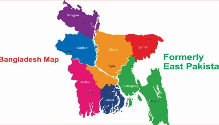
DHAKA – Unlike many of its South Asian neighbors that operate under a provincial system, Bangladesh utilizes a streamlined, two-tier administrative structure to govern its 170 million citizens. At the top of this hierarchy are the 8 administrative divisions, which are further subdivided into a total of 64 districts (locally known as Zilas).
Each division serves as a vital hub for regional governance, while the districts act as the primary units for local administration, justice, and development.
The Northern Frontier: Rangpur and Rajshahi
The northern region of the country is split between the historic Rajshahi division and the relatively newer Rangpur division.
Rangpur Division (8 Districts): Formed in 2010, this northern tip includes Dinajpur, Gaibandha, Kurigram, Lalmonirhat, Nilphamari, Panchagarh, Rangpur, and Thakurgaon.
Rajshahi Division (8 Districts): Known as the “Silk City” region, it oversees Bogura, Chapai Nawabganj, Joypurhat, Naogaon, Natore, Pabna, Rajshahi, and Sirajganj.
The Heartland: Dhaka and Mymensingh
Dhaka remains the powerhouse of the nation, while Mymensingh stands as the youngest division in the country.
Dhaka Division (13 Districts): The most populous division, containing the capital and surrounding industrial zones: Dhaka, Faridpur, Gazipur, Gopalganj, Kishoreganj, Madaripur, Manikganj, Munshiganj, Narayanganj, Narsingdi, Rajbari, Shariatpur, and Tangail.
Mymensingh Division (4 Districts): Established in 2015 to improve administrative efficiency in the north-central region, it includes Jamalpur, Mymensingh, Netrokona, and Sherpur.
The Gateway to the East: Chattogram and Sylhet
This region is defined by hills, tea gardens, and the nation’s primary maritime ports.
Chattogram Division (11 Districts): The largest division by land area, covering the coastal belt and Hill Tracts: Bandarban, Brahmanbaria, Chandpur, Chattogram, Cumilla, Cox’s Bazar, Feni, Khagrachari, Lakshmipur, Noakhali, and Rangamati.
Sylhet Division (4 Districts): Located in the northeast, it is famous for its tea estates and includes Habiganj, Moulvibazar, Sunamganj, and Sylhet.
The Delta and the Coast: Khulna and Barishal
The southwest is characterized by the Sundarbans mangrove forest and a vast network of rivers.
Khulna Division (10 Districts): Bordering India to the west, it houses Bagerhat, Chuadanga, Jashore, Jhenaidah, Khulna, Kushtia, Magura, Meherpur, Narail, and Satkhira.
Barishal Division (6 Districts): Often called the “Venice of the Bengal” due to its waterways, it consists of Barguna, Barishal, Bhola, Jhalokathi, Patuakhali, and Pirojpur.
Quick Stats:
Total Divisions: 8
Total Districts: 64
Largest Division (Area): Chattogram
Most Districts in a Division: Dhaka (13)
Newest Division: Mymensingh (2015)
The administrative landscape continues to evolve as the government occasionally proposes new divisions (such as “Padma” or “Meghna”) to better manage the country’s high population density.